
How to Search West Virginia Property Records
Who owns a parcel in West Virginia? The answer depends on where each piece of the record lives. Deeds sit with the county clerk. The assessor keeps the parcel and value data. A West Virginia property records search usually touches both offices. Tax tickets, court files, plat maps, and old land books round out the picture. A statewide lookup helps you find the right county and parcel number first. Start your search West Virginia property records by county when the location is already known. Statewide tools do not replace a recorded deed or a survey where a boundary line is disputed.
- Choose the county and search IAS by street name, owner, or full parcel ID. Copy the district, map, parcel, and suffix exactly.
- Open the parcel detail and note the deed book and page or other transfer reference shown there.
- Use the county clerk’s index or RECORDhub entry to locate the recorded deed and any release or plat tied to the parcel.
- Check the county assessor and sheriff channels for the tax year, value, and tax ticket status that match the parcel.
- View the parcel in the Property Viewer, then request a recorded plat or survey if a legal line matters.
If an online search comes up empty, call the county clerk, assessor, or sheriff. They can point you to the local counter, the copy process, or a retained book. Older material may also sit on microfilm at the State Archives and History Library.
West Virginia Property Records Offices
West Virginia splits record custody between county offices and state support systems. The county clerk, formally the clerk of the county commission, records deeds, deeds of trust, releases, liens, and plats. The assessor manages the property book and each parcel assessment. The sheriff issues and collects tax tickets. State portals add a shared search layer. They do not fold county records into one statewide deed office.
County Clerk Directory
County clerk and courthouse contacts for all 55 counties.
Property Tax Division
State assessment rules, forms, tax timelines, and county assessor contacts.
WV GIS Technical Center
Statewide parcel data, map services, and GIS metadata.
West Virginia Deed Indexes Vary by County
The West Virginia County Clerk Portal serves as a shared entry point for land-record searches. Participating counties are now moving to RECORDhub. A guest index search is available in documented cases. Document images, account access, and charges vary by county and product. A statewide link never promises the same records everywhere. It also never promises the same image range online.
Pick the county and check its certified-date information before trusting an index. The county selector reveals how date ranges and record types differ. Some counties run a separate clerk search or post their own cutoff notes. A portal may return nothing. Or the parcel may be recorded under an older legal description. In either case, the Secretary of State's county clerk directory helps locate the right office.
For an older deed, ask the clerk which grantor-grantee books, microfilm, or courthouse index covers the year you need. A blank online image proves nothing either way. The recorded copy carries far more weight. Its indexing date does too.
Note: Confirm coverage after selecting the county, because one statewide portal can contain different date ranges and image rules across its participants.
Types of West Virginia Property Records
West Virginia property records answer different questions and answer to different custodians. A deed documents a filed transfer. The assessor's land book supports taxation. The sheriff's ticket shows the bill and its payment path. Court cases, plats, and archive entries add context. But none replaces the record held by the proper office.
| Record Type | What It Documents | Kept By | Access |
|---|---|---|---|
| Deeds and releases | Transfers, deeds of trust, releases, liens, and recorded plats | County clerk | County index, clerk counter, or participating RECORDhub search |
| Assessment and tax | Owner field, land and building values, classification, and tax ticket | County assessor and sheriff | IAS statewide search plus local correction and collection channels |
| Parcel maps | Tax parcel shape, map key, and location context | WV Property Viewer, assessor, and GIS providers | Public viewer, downloads, or printed county maps |
| Court records | Publicly accessible cases that may affect property rights | Circuit or magistrate clerk | WVPASS, Magistrate Record Search, or clerk copies |
| Historic land books | Older deed, survey, tax, probate, and land references | County clerk and State Archives | Office books, microfilm, and archive finding aids |
Need proof of a recorded transfer? Work through the county clerk's deed index. Then pull the instrument image. The West Virginia deed records page walks the grantor-grantee route. For an assessed amount or a tax bill, begin with the assessor and sheriff. Then follow the property tax record steps for the bill and review process. A parcel map orients a location and reveals neighboring parcel keys. These searches connect, yet each source keeps its own update date and legal role.
Note: Read each record with its own date and custodian; a statewide search result is an index aid, not a combined title or tax history.
IAS Fields for a West Virginia Parcel
The state IAS search offers basic, appraisal and sales, advanced, and prior-ownership modes. Start with a county and district when the street name is common. After a first result, the full parcel ID becomes the strongest key. The portal also searches by owner name, street, map, parcel, and sub-parcel. Advanced filters cover property class, tax class, land use, acreage, and value. More filters add sale date or price, mailing address, and legal description. Building year and building area can also be filtered.
| Search field | Use it for | Care to take |
|---|---|---|
| County and district | Narrow the statewide roll to the tax district | Postal city names do not define county custody |
| Full Parcel ID | Return to a known parcel | Keep the district, map, parcel, and suffix zeros |
| Owner name | Find parcels under a person or entity name | Open details; one result row may omit co-owners |
| Street name | Review parcels along a road or block | Rural and incomplete address rows can be missed |
| Appraisal and sales filters | Focus on value, acreage, or transfer data | Assessment is not a current market appraisal |
IAS results cap at 1,000 and include a CSV export. A result card may show the current owner of record, physical and mailing addresses, legal description, land, building, and total appraisal, sales history, deed book and page, parcel history, and building facts where reported. The sample assessment detail displays these categories on a single parcel record.
- Parcel ID
- The assessment key assembled from district, map, parcel, and suffix segments.
- Situs address
- The physical location attached to a parcel, distinct from where tax mail is sent.
- Owner of record
- The owner name carried in an official record at its stated date.
- Legal description
- The land description, which may use lot and block, acreage, or metes and bounds.
When West Virginia Assessment Data Changes
West Virginia fixes ownership, use, and value for the coming tax year each July 1. Public-service business property uses a different date. County assessors start their annual work on July 1 as well. The land and personal-property books are due January 30. The result is a dated yearly assessment, not a live feed of sales.
Two clocks govern updates. Under W. Va. Code §11-4-8, each county clerk sends the assessor a certified list of the prior month's title transfers. It is due by the tenth day of the month. The state's public viewer, though, refreshes property data just once a year. The refresh comes when the new assessment release posts. Local assessors can correct details at the county level before that release. No statewide count of lag days exists for every county's online owner field.
For a recent closing, set the newest deed's recording date beside the assessor card. Note which source is newer. Parcel-line changes move slower than a name fix. That lag grows where the county map still lives on paper.
Note: A monthly transfer list does not mean every statewide screen changes monthly; check the county assessor when a fresh deed is not reflected.
Reading West Virginia Parcel Maps
The statewide viewer accepts E-911 address, owner and parcel attribute, and geometry searches. Basemaps can pair parcels with roads, imagery, topography, and context layers. Geometry options run from point and rectangle to polygon and a point buffer. Identify and measure tools help inspect the map. Help documentation caps desktop results at 1,000. A broad geometry query may need narrowing.
The IAS parcel key opens with a two-digit district. Map, parcel, and suffix segments follow, each four digits. Keep leading zeros and use the exact root ID. One county may hold multiple cards, split surface and mineral interests, or a parcel line trailing a recent survey. Some assessors sell printed PDF maps at the counter.
State GIS Clearinghouse dataset 371 carries statewide surface-parcel products as geodatabases, shapefiles, PDFs, and TIFFs. Metadata lists identifiers such as Parcel Identifier, CleanParcelID, and GISPID, plus owner, legal description, and county code. Assembled for taxation from available records, the data is not field verified.
Map limit. A tax parcel line is a reference view, not a valid survey plat or conclusive evidence of title. Use the recorded plat and a licensed surveyor for a boundary dispute.
Older West Virginia Land Books
Paper books still anchor West Virginia property research. County clerks hold the recorded land instruments. The West Virginia Archives and History Library keeps microfilm and finding aids for deeds, surveys, land books, tax records, wills, and court material.
Holdings differ by county. Confirm the county and record series before any visit or request.
The Archives' finding aid lists deed books, grantor-grantee indexes, surveyor books, and land books. Pull a land-book or survey reference to a likely instrument. Then check the county clerk's book and page for the filed record.
Keep written requests narrow. Published service rules limit staff research to half an hour. They also allow two specific questions. Fees depend on patron status plus copy and postage needs. A finding aid points to a record group. It is no substitute for the original deed or a full ownership opinion.
The State Archives also keeps city and telephone directories for year runs. Coverage includes Charleston, Huntington, Wheeling, Morgantown, and other places. A directory can tie an old street or household to a period. It names an occupant, though, not the legal owner.
West Virginia Court Records and Land Claims
A lawsuit can touch a parcel through a lien, foreclosure, quiet-title claim, partition, or an order directing a sale. The West Virginia Judiciary Court Record Access page routes the public to WVPASS for circuit-court records. Circuit materials searchable online date to 1999. Access and document availability still vary by case. Circuit clerks handle older, sealed, restricted, or incomplete files.
Magistrate cases sit in a separate statewide search. Copies come from the magistrate clerk. A court file gives a docket and filings. It is not a current assessor value, nor automatic proof that a judgment still binds a parcel.
Start with the county and the parties. Record the case number and filing date. Track the complaint, lis pendens, judgment, decree of sale, confirmation, and any commissioner or sheriff deed. Compare the outcome against later county-clerk instruments, releases, and the parcel's legal description.
Note: A case docket locates filings, but later recordings and release records can change what a property search should report.
West Virginia Delinquent Land Records
Delinquent land follows its own paper trail. County sheriffs collect real-property taxes and post tax-sale notices. The State Auditor's County Collections system covers property certified to the state or handled by a deputy land commissioner. Its search accepts a name, county, certificate, description, district, municipality, map, parcel, book and page, account, or status. That range of fields makes it a strong tool for tracing a certified parcel.
A result is a lead, not a conclusion. Check anything it returns with the county and the tax-sale office. Sheriff sale dates shift. Redemption rights and payment rules change too. The statewide results page can even come back empty while a county still holds current delinquent records, so ask locally before giving up.
Before acting on any distressed listing, confirm the tax year, legal description, current owner of record, sale status, redemption period, and payment route with the responsible county office. A tax-sale list is not a title report. Treat it as a starting point rather than an auction guarantee. The statewide sheriff tax-sale page spells out the sale and redemption cautions, and the State Auditor's County Collections search covers both the certified-to-state and deputy land commissioner routes. The fields below help narrow an entry by county and parcel.
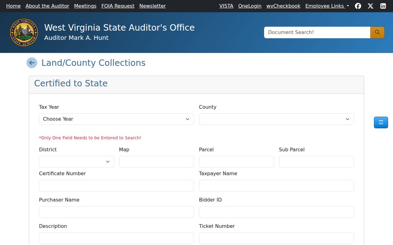
These fields narrow a state-certified entry. Confirm parcel status and sale terms with the county sheriff or the Auditor before acting on any result.
Note: A posted sale page may lag the sheriff’s current instructions, so confirm live terms before sending funds or joining a sale.
Limits of West Virginia Property Records
A public record shows what an office recorded or assessed at one point in time. It cannot settle every title question. It cannot prove who lives at a parcel. It cannot certify a boundary line. Ownership fields can be murky too. A trust, LLC, estate, co-owner, or protected mailing address may sit between you and the real owner of record. Treat a name match as a clue only. Compare the parcel number, legal description, instrument date, and county before calling two records the same property.
West Virginia's Freedom of Information Act, W. Va. Code chapter 29B, opens inspection and copying of public records unless an exemption applies. Section 29B-1-3 sets the access and response rules, and section 29B-1-4 lists the exemptions. Send each request to the custodian. Name the county, office, parcel or account, record type, date range, and format you want. The law never forces an office to build a statewide parcel list or run a title analysis. A custodian may hand over a record without judging its legal effect.
Match the record to the question. A deed or boundary dispute calls for the clerk's filed instrument, the recorded plat, and qualified title or survey work. An assessment error belongs with the county assessor. Keep each record's scope in mind during a purchase review. Keep it in mind during an estate matter, a tax appeal, or civic research.
Lawful use. Use owner information for a legitimate property or civic purpose. Do not republish protected details or use a public record to stalk, threaten, harass, or harm someone.
West Virginia Address Privacy Rules
A parcel in West Virginia carries several address fields. Situs address, tax-mailing address, and legal description are distinct entries. The mailing address may point to an owner or an agent. It may instead list a trust, a P.O. box, or a participant in the Address Confidentiality Program. Treat it as a contact point, not proof of where someone lives. A street address can also carry a postal city name. That name may cross county or municipal lines.
West Virginia's Address Confidentiality Program serves eligible survivors. It covers domestic violence, sexual assault, stalking, and human trafficking. It supplies a substitute address and forwards mail. A trained assistant handles the application. Certification generally lasts four years. The Secretary of State ACP page spells out the process and its statutory limits. Keep in mind that an old deed recorded before enrollment may still sit in public archives. A copy held by a third party may too.
When an address is missing or inconsistent across property records, resist the urge to guess. It does not mean the owner lacks a residence or that a record is false. Ask the custodian which field you are viewing and when it was sourced. Honor any protected-address process in place. Then let the deed, the assessor roll, and the plat or GIS map each answer only the question they were built to answer.
Note: Postal ZIPs and city labels are not legal boundaries; compare the assessor district and municipal GIS layer before assigning jurisdiction.