
West Virginia Property Search Route
An address is the best starting point. It works when the question is tied to a known place. The WV Property Viewer draws on E-911 address points. It opens a parcel result on a match. If that fails, the IAS Property Search offers a Street Name field. It also filters by county, district, map, parcel, or owner. Copy the full parcel ID and the legal description. Those two details carry a property search into older records. A current street name may not appear there.
Keep three clues separate once a match opens. The physical address locates the land. The owner mailing address shows where tax notices go. The parcel key ties later assessment searches to the same tract.
- Enter the physical address in the WV Property Viewer, including the city and WV abbreviation. If no result appears, try a shorter street form.
- Use the IAS Street Name search and select the county. Narrow the list by district, map, parcel, or owner name when the street returns many rows.
- Open the parcel detail. Copy the Root Parcel ID, the physical and mailing addresses, the legal description, and the deed book/page reference.
- Use the exact parcel key in IAS Prior Ownership or Appraisal/Sales modes. Compare the current row with the older parcel history and sale entries.
- Take the owner name or deed reference to the county clerk's index when the goal is the recorded instrument. The assessor result is a route to that record, not a substitute for it.
- Situs address
- The physical location assigned to a parcel or structure; it can differ from the address used for tax mail.
- Parcel ID
- The assessor's tax key, built from district, map, parcel, and suffix parts.
- Owner of record
- The owner name shown on the assessment row or card, which should be checked against the latest deed for a recent transfer.
West Virginia IAS Search Fields
The statewide IAS Property Search groups its controls under several modes. These include Basic, Appraisal/Sales, Advanced, and Prior Ownership. Most fields are optional. The choices shown can shift with the county and the mode selected. County is not required on the first screen. It is still essential for a useful county property records query.
| Field or control | Type | Required | Format or use |
|---|---|---|---|
| County | Dropdown | No at first screen | Select one of West Virginia's 55 counties to narrow a query. |
| District | Dropdown | No | County-dependent tax or municipal district. |
| Full Parcel ID | Text | No | Enter the full IAS or root parcel identifier. |
| Owner Name | Text | No | Partial owner name is accepted; exact-match behavior is not stated. |
| Street Name | Text | No | Can return multiple parcels on a street or road. |
| Map Number | Text | No | Tax-map segment. |
| Property Class | Dropdown | No | Visible options depend on the selected county. |
| Parcel | Text | No | Tax-map parcel component. |
| Tax Class | Dropdown | No | State and local tax-class choices. |
| Sub-Parcel | Text | No | Subparcel component. |
| Land Use | Dropdown | No | State land-use codes; the live list varies. |
| Min/Max Land Appr | Numeric range | No | Minimum and maximum land appraisal. |
| Min/Max Building Appr | Numeric range | No | Minimum and maximum building appraisal. |
| Min/Max Calc Acres | Numeric range | No | Calculated acreage range. |
| Sale From / Sale Through | Date range | No | Sale-date range using the portal's date control. |
| Min/Max Total Appr | Numeric range | No | Total appraisal range. |
| Min/Max Price | Numeric range | No | Recorded or assessment sales-price range. |
| Min/Max Deeded Acres | Numeric range | No | Deeded acreage, which can differ from calculated acreage. |
| Flood Hazard | Dropdown | No | Flood-hazard filter. |
| Mailing Address | Text | No | Owner or tax-mail address, separate from the situs address. |
| Deed Book | Text | No | Recorded book reference. |
| Page | Text | No | Page within the deed book. |
| Legal Description | Text | No | Searchable description text. |
| Building Year Min/Max | Numeric range | No | Structure age range. |
| Primary Structures Min/Max | Numeric range | No | Count range for primary structures. |
| Building Area Min/Max | Numeric range | No | Building-area range. |
| Secondary Structures Min/Max | Numeric range | No | Count range for secondary structures. |
| Lines per page | Numeric or select | No | Controls the result display. |
| Display legal description | Checkbox | No | Adds the legal description to result rows. |
| Display GIS parcel ID | Checkbox | No | Adds the GIS parcel identifier to results. |
| CSV Results | Link or button | No | Downloads the result table after a search. |
A broad query can return as many as 1,000 matches on a paginated list. Add a filter before treating a long result set as complete. Use a county, street, owner, or parcel filter to narrow the matches. The CSV option helps when a large table needs sorting or comparison.
Note: IAS field names and choices vary by county. Save the county and search mode with any result.
West Virginia Property Search Results
A search result ties a name to the essentials. You get a parcel key, an address, and a land description. Open a sample West Virginia assessment card. You will see how much detail sits behind a single row. Treat it as a lead. It is not a certified deed, appraisal, survey, or title opinion.
The IAS search page lays out the field groups this property search uses.
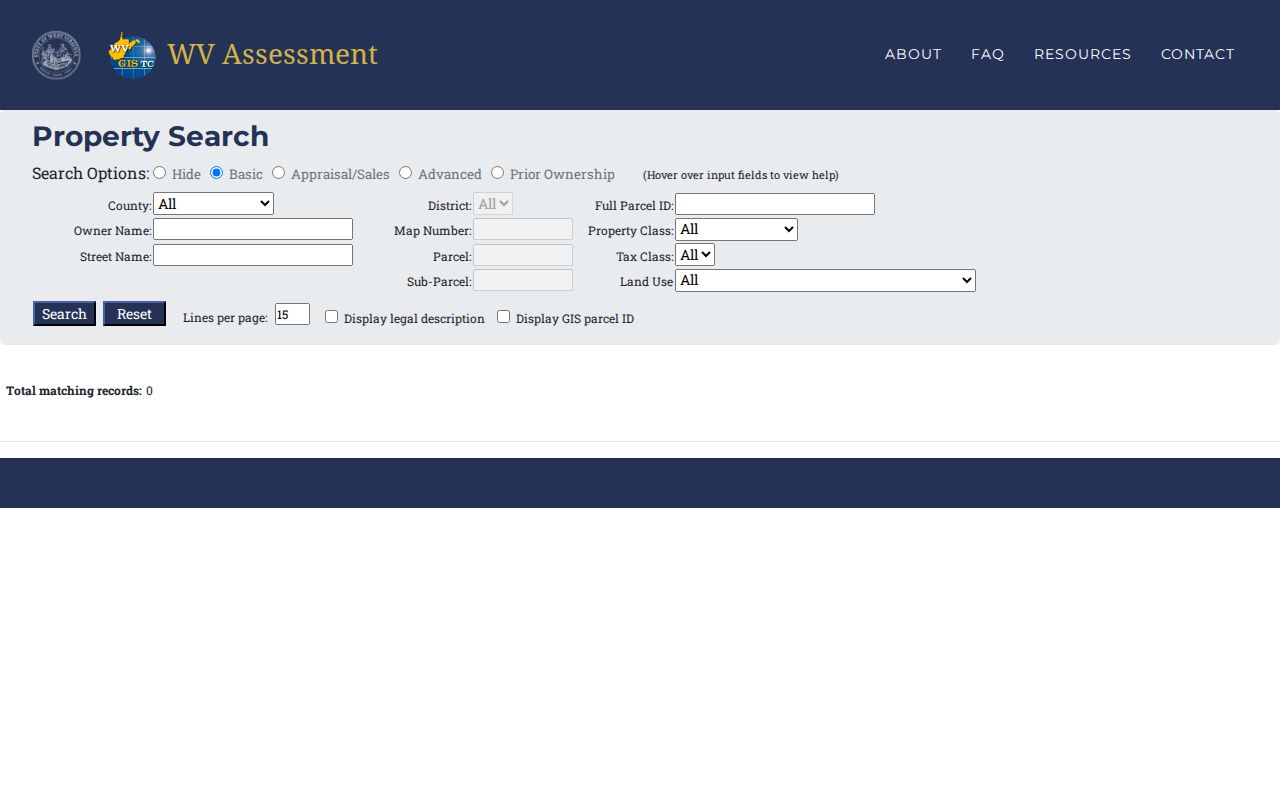
The field set moves a searcher from a broad address query to one specific assessment card. One visible row is never the whole ownership history.
| Identity | Root Parcel ID, current owner, county, district, map, parcel, and GIS map link. |
|---|---|
| Addresses | Physical or situs address and a separate owner or mailing address. |
| Land description | Legal description, deeded acres, calculated acres, and map references. |
| Classification | Property class, tax class, and land-use code. |
| Appraisal | Land appraisal, building appraisal, and total appraisal. |
| Sales history | Sale date, price, sale type, source code, validity code, and book/page when available. |
| Parcel history | Prior tax years, owners, owner addresses, legal descriptions, book/page, and land, building, and total values. |
| Building details | Card number, year built, attic, fuel, heat system, heat or air conditioning, bedrooms, full and half baths, total rooms, and structures when reported. |
| Other detail | Flood-zone acres and risk, plus links to an assessment report and PDF map. |
In the sample, sales history included dates, prices, sale types, source and validity codes, and deed book/page references. Parcel history carried tax-year rows plus a legal description for a named addition. These fields point toward source documents. The assessment card itself is not the document.
Address Search in West Virginia
The E-911 Address search in the WV Property Viewer uses SAMS address data. Enter a street address with a city and state abbreviation. Rural routes and post office boxes are excluded, so those forms may not match. Apartment numbers, renamed streets, old rural routes, and postal-city labels can also produce a blank result. They can produce a misleading property search as well.
Shorten the entry when the exact address returns no parcel. Then try the IAS Street Name field. The state viewer uses SAMS for E-911 addresses. IAS relies on its own address and owner/parcel data. The same address can behave differently in the two systems. A street-level query reveals candidate parcels. It may still omit parcels with no address or incomplete address data.
Keep the two address fields separate. The physical or situs address identifies the land's location. The mailing address tells where assessment or tax notices go. The owner address may sit off-site. It may belong to an agent or trust. It may also serve as a protected substitute. A ZIP or postal city never proves a parcel falls inside a city limit. It never proves the county named on a mailing label either.
Note: If an address changed, use the legal description and parcel key to reconnect older records. Do not force the modern street name into every search.
Owner Name Search in West Virginia
The Property Viewer demands a county before an owner search will run. Partial names are accepted. The help notes that “Smith” or “Smith J” may return “Smith John.” Enter combined names as LASTNAME FIRSTNAME. In IAS, an Owner Name search can be paired with district, street, class, land use, acreage, appraisal, or sale filters. Extra detail cuts down unrelated matches.
Owner data rarely lines up perfectly. One owner may appear in the assessment row while the parcel card lists several. Spelling, punctuation, married names, entity suffixes, a trustee, or an estate representative can each shift the outcome. Watch for these quirks. Open the parcel detail first. Record every owner field before carrying a name forward. An LLC's registration record can pin down the exact entity string. Even so, it proves nothing about land title.
Trusts and estates call for two searches. Run the exact assessment name plus any trustee, executor, or administrator who appears in the deed trail. A family transfer may sit under a personal name. The newest tax row may carry an estate or trust label instead. Results shape the next query. They never prove that two people sharing a name are the same person.
Parcel IDs in West Virginia
The statewide IAS parcel key opens with a two-digit district. It then has four-digit map, parcel, and suffix segments. The segmented example in the help is 01 2345-6789-0123. Hyphens are optional. The portal takes the full ID without them. Copy the identifier exactly as printed on the result. Zero padding differs between the map-number examples and the standardized parcel display. Rebuilding an ID from memory invites mismatches.
Keep the Root Parcel ID and GIS parcel ID together. They are related, not identical. Statewide GIS metadata also names CleanParcelID and GISPID as join fields. A surface interest, mineral interests, or several assessment cards can attach to a single parcel. The GIS key connects the two. The viewer warns about assessment information. It does not display every card of a unique parcel.
Note: Deeded acres and calculated acres can differ. Carry both values with the legal description whenever a parcel is split or combined.
Compare West Virginia Search Keys
Match the search key to what you already know. An address nails down a current location fast. An owner name can surface multiple parcels, while the parcel ID is the most stable bridge between the assessment system and later record checks.
Every mode has a weak point. Addresses run incomplete, owner names get normalized or shared, and parcel IDs demand every segment value. Confirm with a second key. Carry a verified match into the deed or tax record.
| Search key | Best starting point | What it returns | Common limit |
|---|---|---|---|
| Address | Property Viewer E-911 search | Candidate parcel and physical location | Rural routes, post office boxes, renumbering, or incomplete address data can miss. |
| Owner name | Property Viewer or IAS | Assessment rows under a name | Co-owners, trusts, estates, punctuation, and same-name people need checking. |
| Parcel ID | IAS or Property Viewer | Parcel-level assessment and map links | Keep the full printed identifier and distinguish tax and GIS keys. |
A property search is not a title search. The West Virginia assessment row and clerk index can help locate recorded documents, but they do not prove that title is clear or that every interest is shown. For a purchase or title dispute, rely on the deed record and a qualified title review.
When the Owner Field Is New
Two labels cover the same idea. The IAS result says “Current Owner.” The detail card says “Property Owner.” Both fields belong to the assessment record. The state viewer refreshes it annually when new assessment data is released. A just-recorded deed can therefore appear in county records before the statewide viewer catches up. No fixed number of days is published.
Timing rests on a monthly handoff. West Virginia Code §11-4-8 requires the county clerk to send the assessor a certified transfer list by the tenth of each month. That statutory deadline still does not promise a date for the new name in the public IAS result. For a just-recorded transfer, compare the deed's recording date and parties with the assessment card's tax-year history. Do the two differ? Keep both dates instead of treating the older assessment entry as the final answer.
Some parcels need the local office. Start there for gaps. The official county assessor roster reaches the right place when a parcel is absent, split, misspelled, or waiting on a correction. For the recorded instrument itself, the West Virginia deed records process explains the county clerk index and the county-specific online cutoff.
GIS Links from a Property Search
Geometry searches accept a point, rectangle, or polygon. A point can carry a buffer. Clicking a result opens the map view, zooms to the parcel, and rows can show a GIS ID, owner name, and address. Desktop help sets a 1,000-result limit. These tools help identify candidate parcels around a known place, but the geometry is not a title boundary.
The WV GIS Technical Center statewide parcel dataset provides tax-year surface parcel files. Formats include geodatabase, shapefile, PDF, and TIFF. Metadata names Parcel Identifier, CleanParcelID, GISPID, Property Owner, Legal Description, and County Code. Downloads help compare identifiers across a set. Not every attribute is included, and the state directs users to county assessors for more current files.
Boundary disputes need better evidence. Start with the plat or deed description. Obtain a licensed survey when needed. The GIS line is a best-fit tax visualization based on available records, not a field-verified survey. The West Virginia parcel map page covers how to compare map layers with plats and survey evidence.
Note: Preserve the dataset's tax year and source date whenever you save or compare GIS results.
When an Online Search Misses
A blank screen is not the end of the story. Records often sit in books that no search engine reaches. Before giving up, swap the search key. Trim the address down to a street name. Try a partial owner of record spelling. Or pull the parcel number off a paper tax bill or deed. A surname may have shifted over the years. So run both the grantor and grantee spellings on the most recent instrument. Keep the county, district, and legal description handy. A clerk or assessor needs them to pin down the right tract.
Newly split or missing parcels belong to the assessor, who corrects the land book and the tax roll. For deed books, plats, indexes, or images, ask the county clerk directly what is available at the counter. The statewide West Virginia County Clerk Directory lists courthouse contacts for all 55 counties. A clerk can work through older books even where a public portal halts at a certified date.
A record may exist but never make it online. The West Virginia Freedom of Information Act opens another door. Send the custodian a written request. Name the office, parcel, record group, date range, and the format you want. The law gives the custodian five business days, excluding weekends and legal holidays, to respond. Note: The custodian need not build a new index or do legal research for you. Reproduction costs are allowed, but not charges for search or retrieval labor.
A property search on a screen is only one route through West Virginia property records. The counter still carries you past an incomplete address. The assessor, the clerk's deed records, and a formal public-record request carry you past an image fee or a missing year.